Trail Mountain bike Le Tholonet - Plateau de Bibémus - Aix-en-Provence - Photo

Plateau de Bibémus - Aix-en-Provence

 tracegps
tracegps

User

© OpenStreetMap contributors
Length
Length
10.6 km
Max alt
Max alt
354 m
Uphill gradient
Uphill gradient
252 m
Km-Effort
Km-Effort  
14 km
Min alt
Min alt
188 m
Downhill gradient
Downhill gradient
249 m
Boucle
Boucle
Yes
Creation date :
2014-12-10 00:00:00.0
Updated on :
2014-12-10 00:00:00.0

(0 Reviews)

Mountain bike
Mountain bike
1h00
Difficulty : Medium

Scan this QR Code to open this trail in the SityTrail application

FREE GPS app for hiking

Logo SityTrail SityTrail

IGN / Geographical institutes

Download SityTrail from the App Store Download SityTrail from Google Play

Logo SityTrail SityTrail World

The world is yours!

Download SityTrail from the App Store Download SityTrail from Google Play Download SityTrail on Huawei AppGallery

About

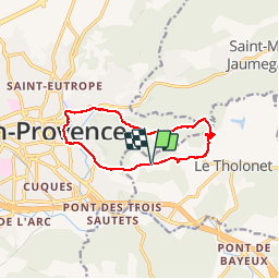
Trail Mountain bike of 10.6 km to be discovered at Provence-Alpes-Côte d'Azur, Bouches-du-Rhône, Le Tholonet. This trail is proposed by tracegps.

Description

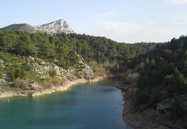
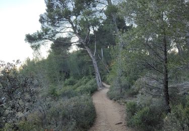
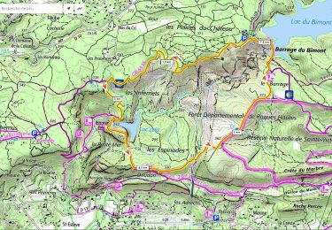
Tracé mixte pour VTT/VAE : route et tous chemins. Depuis la ville d'Aix-en-Provence, l'on gagne le plateau de Bibémus sur une route goudronnée. Bel aperçu de la Sainte Victoire. La promenade se poursuit sur un chemin de terre, pour rejoindre la route Cézanne (ici nombreuses variantes possibles). Retour vers Aix en passant au pied de Château Noir, fief de Cézanne. Les principaux points de bifurcation sont (coordonnés en degrés décimaux) : Accès chemin de Bibémus : 43.53488, 5.46821 Parking plateau de Bibémus : 43.53118, 5.50058 Bifurcation au vers Le Tholonet : 43.53238, 5.50339 Jonction Route Cézanne : 43.523358, 5.502355

Elevation profile

Photos

Positioning

Country:
France
Region :
Provence-Alpes-Côte d'Azur
Department/Province :
Bouches-du-Rhône
Municipality :
Le Tholonet
Location:
Unknown
Start:(UTM)
700948 ; 4821790 (31T) N.

Trails nearby

Trail Walking Aix-en-Provence - Circuit des lacs Zola et Bimont - Aix-en-Provence - Photo
Walking
tracegps

Walking

Medium
(4)
Aix-en-Provence, Provence-Alpes-Côte d'Azur, Bouches-du-Rhône, France
10 km | 13.6 km-effort
2h 30min
Yes
Trail Walking Saint-Marc-Jaumegarde - Barrages Zola-Bimont - Photo
Walking
Berpav

Walking

Medium
(2)
Saint-Marc-Jaumegarde, Provence-Alpes-Côte d'Azur, Bouches-du-Rhône, France
8 km | 11 km-effort
2h 30min
Yes
Trail Walking Saint-Marc-Jaumegarde - La Croix de Provence depuis le barrage de Bimont - Photo
Walking
tracegps

Walking

Difficult
(1)
Saint-Marc-Jaumegarde, Provence-Alpes-Côte d'Azur, Bouches-du-Rhône, France
13.9 km | 24 km-effort
4h 45min
Yes
Trail On foot Beaurecueil - Sentier Imoucha - Photo
On foot
PRO

On foot

Easy
Beaurecueil, Provence-Alpes-Côte d'Azur, Bouches-du-Rhône, France
4.4 km | 10.1 km-effort
2h 17min
No
Trail Walking Aix-en-Provence - Aix En Provence - St Beaume - Photo
Walking
Geckos

Walking

Difficult
(1)
Aix-en-Provence, Provence-Alpes-Côte d'Azur, Bouches-du-Rhône, France
65 km | 94 km-effort
19h 29min
No
Trail Walking Le Tholonet - le tour des barrages - Photo
Walking
GUIDE
amiral13

Walking

Easy
(1)
Le Tholonet, Provence-Alpes-Côte d'Azur, Bouches-du-Rhône, France
10.9 km | 15.5 km-effort
6h 4min
Yes
Trail Walking Aix-en-Provence - Randonnée des barrages Zola et Bimont - Photo
Walking
dudu42

Walking

Medium
Aix-en-Provence, Provence-Alpes-Côte d'Azur, Bouches-du-Rhône, France
10.4 km | 14 km-effort
2h 22min
Yes
Trail Walking Le Tholonet - Le Tholonet -La Croix de Provence Par les Lacs Zola et Bimont - Photo
Walking
donda

Walking

Very difficult
Le Tholonet, Provence-Alpes-Côte d'Azur, Bouches-du-Rhône, France
21 km | 34 km-effort
6h 17min
Yes
Trail Walking Saint-Marc-Jaumegarde - Barrage Zola depuis le barrage de Bimont - Photo
Walking
ericberlin

Walking

Medium
Saint-Marc-Jaumegarde, Provence-Alpes-Côte d'Azur, Bouches-du-Rhône, France
7.5 km | 10.5 km-effort
2h 23min
Yes


Close
My subscriptions